Kuakata Beach of Bangladesh: see Beach of the world

Kuakata Beach of Bangladesh: see Beach of the world

Kuakata is a panaromic sea beach on the southernmost tip of Bangladesh. Located in the Patuakhali district, Kuakata has a wide sandy beach from where one can see both the sunrise and sunset. It is about 320 Kilometres south of Dhaka, the capital, and about 70 Kilometres from the district headquarters. The Kuakata beach is 30 km long and 6 km wide. On 13 September, 2007 government had announced a red alert in Kuakata as caution for a possible Tsunami.

The name Kuakata originated from the word 'Kua'-the Bengali word for “Well” which was dug on the sea shore by the early Rakhine settlers in quest of collecting drinking water, who landed on Kuakata coast in the eighteenth century after being expelled from Arakan (Myanmar) by the Mughals.[3] Afterwards, it has become a tradition of digging Well in the neighborhoods of Rakhaine tribes for water.

Kuakata offers a full view of the sunrise and sunset from the same white sandy beach in the water of the Bay of Bengal.

Locally known as Shagor Khan-Ya (Daughter of the Sea), the long strip of dark, marbled sand stretches for about 30km. The long and wide beach at Kuakata has a typical natural setting. This sandy beach has gentle slopes into the Bay of Bengal. Kuakata is also a sanctuary for migratory winter birds.

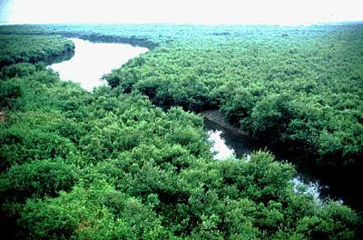
On the eastern end of the beach is Gongamati Reserved Forest, an evergreen mangrove forest and snippet of the original Kuakata. When the Rakhines settled in the area in 1784, Kuakata was part of the larger Sundarbans forest. However, the Sundarbans is now at a distance of one-hour by speed boat. As a mangrove forest, Gongamati, like the Sundarbans, offers some protection against tidal surges, however it too is being threatened by logging and deforestation. The best way to reach the forest is by foot or bike along the beach, where a flock of flag flying fishing boats can be seen trawling the coast. Choosing to visit Gangamati in the late afternoon is a perfect time to watch the sun caste shadows on the abstract exposed mangrove roots.

Kuakata is the place of pilgrimage for both Hindu and Buddhist communities. Innumerable devotees arrive here at the festival of 'Rush Purnima' and 'Maghi Purnima'. On these two occasions the pilgrims take holy bath at the bay and participate in the traditional fairs. One may also visit the 100 years old Buddhist Temple where the statue of Goutama Buddha and two wells of 200 years old are located.

Fisherman village is another place where you can visit and watch the lifestyle of the Fisherman. If you are adventurous you may also go for fishing on the fishing boat if you can manage the local fishermen. That will give you pleasure and experience, which you won’t be able to gather from anywhere else. In the fishermen village you will find the fishermen coming back from the sea and you can purchase some fresh Hilsha fish from them, and by the side of village there are some local restaurants from where you can get the Hilshas cooked and ready for eating.

The government and local business owners have made significant developments over the years to attract tourist to its shores. Now a days, local people are more supportive to the tourists and communications have improved significantly. A new Police station was built in 2007. Accordingly, the law and order situation in the open beach, even at night, has improved significantly.
by:wikipedia


by:www.youtube.com

Kuakata Beach of Bangladesh: see Beach of the world


by:www.youtube.com

National symbols of Bangladesh


It is probably unimaginable to reflect the suffering that the people of East Pakistan went through to win for themselves one of the most fundamental rights of mankind - Freedom of Speech. People in East Pakistan were restricted by the Central Pakistani government to only use Urdu as their medium of instruction and the official language, and give up their own beloved language, Bangla. Foregoing the language that was central to their ethnological identity was a very unpleasant option for the constituents of the Eastern wing of Pakistan. The Central government demanded that Urdu be the state language for the entire Pakistan,http://www.mtholyoke.edu/~rahma20m/050303-dhaka-01.jpghttp://www.mtholyoke.edu/~rahma20m/050303-dhaka-01.jpg as Urdu was the dominant language in the western part. The general populace of the Eastern part of Pakistan was not ready to embrace Urdu and learn a new language in order to facilitate this forced imposition by the government. Instead of complying, the determined citizens of East Pakistan wanted to defy the odds and protested to retain their mother tongue. A group of students and political activists of University of Dhaka and Dhaka Medical College decided to protest against the oppression meted out to the Bangla-speaking population. They initiated a movement and demanded that Bangla be given equal status as Urdu, and for both to be enshrined as the state languages of Pakistan. The police fired upon the youths and made them the martyrs who epitomized the value of self-determination; their sacrifice set a new precedent for the country to demand their Freedom of Speech. This brutal atrocity took place on 21 February, 1952.


http://www.radisson.com/rad/images/hotels/BANDHAKA/National%20Memorial%20(450%20x%20299).jpg

The original fortification wall on the south has five bastions at regular intervals, and the western wall has two. Among the seven bastions, the biggest one is near the main southern gate at the back of the stable, which occupies the area to the west of the gateway. The bastion has an underground tunnel. Among the five bastions of the southern fortification, the central one is single-storeyed, while the rest are double-storeyed structures. The central one contains an underground room with verandahs on three sides, and it can be approached either from the riverside or from its roof. The double-storeyed bastion at the southwestern corner of the fort is possibly a Hawakhana, with a water reservoir on its roof.

http://www.columbia.edu/itc/mealac/pritchett/00routesdata/1600_1699/jahangir/dhaka/photomod1.jpg

Kazi Nazrul Islam was born in the village of Churulia in the Burdwan District of Bengal (now located in the Indian state of West Bengal).He was born in a Muslim family who is second of three sons and a daughter, Nazrul's father Kazi Fakeer Ahmed was the imam and caretaker of the local

https://blogger.googleusercontent.com/img/b/R29vZ2xl/AVvXsEiQYlsHnBxuLtAbIJ1IItBKu0caoLHGTWxbSKbd4yW90qHcpeV-jkvl6IjWfQVwRjw3J7BxswT3z8gX2_6IRqx3UdOZSbAX5BFPVn2v4HPYwX1Mph4kcY94Tl2BXsj-qsAXI-acy8bBw5c/s400/ni1.gifmosque and mausoleum. Nazrul's mother was Zaheda Khatun. Nazrul had two brothers, Kazi Shahebjan and Kazi Ali Hussain, and a sister, Umme Kulsum. Nicknamed Dukhu Mia (Sad Man), Nazrul began attending the maktab — the local religious school run by the mosque — where he studied the Qur'an and other scriptures, Islamic philosophy and theology. His family was devastated with the death of his father in 1908. At the young age of ten, Nazrul began working in his father's place as a caretaker to support his family, as well as assisting teachers in school. He later became the muezzin at the mosque, delivering the Athan and calling the people for prayer.

The Rivers of Bangladesh

There are many rivers in your country in Bangladesh Rivers of Bangladesh look like very nice ful

The Jamuna Bridge is currently the 12th longest bridge in the world, according to available information, and provides the first fixed crossing of the Jamuna River linking eastern and northwestern parts of Bangladesh. The location of the bridge is shown on the map alongside. It crosses the Jamuna River (the main channel of the Brahmaputra River in Bangladesh) from Bhuapur on the East Bank to Sirajganj on the West.

The Jamuna River is one of the three main rivers of Bangladesh. It serves as the main branch of Brahmaputra River, which flows through Tibet (China) and India.

The Jamuna was a barrier in establishing a direct road link between capital Dhaka and northern part of Bangladesh better known as Rajshahi Division until 1996, with the completion Jamuna Multi-Purpose Bridge.

It is one of the largest bridge in the World and a great bridge. It’s structure and size will attract you and specially the views of it.

You can take a river cruise in the Jamuna which will give refreshment to you. There is boats availabe in the Jamuna River.

Agunmukha river

The Jamuna Bridge is currently the 12th longest bridge in the world, according to available information, and provides the first fixed crossing of the Jamuna River linking eastern and northwestern parts of Bangladesh. The location of the bridge is shown on the map alongside. It crosses the Jamuna River (the main channel of the Brahmaputra River in Bangladesh) from Bhuapur on the East Bank to Sirajganj on the West

Construction of the reservoir for the hydro-electric plant began in 1956. As a result, 54,000 acres (220 km2) of farmland in the Rangamati District went under water and created the lake.

The hydro-electric project was funded by the United States. The project was finished in 1962. International Engineering Company and Utah International Inc. received the contract for construction of the dam. The dam is 670.6 meters long, and 54.7 meters high. The dam has a 745 feet (227 m) long spillway containing 16 gates. Through the spillway 5,250,000 cusec of water can pass every second

http://voiceofsouth.files.wordpress.com/2007/07/sun_setting_in_agunmukha_river.jpg

The rivers of Bangladesh mark both the physiography of the nation and the life of the people. About 700 in number, these rivers generally flow south. The larger rivers serve as the main source of water for cultivation and as the principal arteries of commercial transportation. Rivers also provide fish, an important source of protein. Flooding of the rivers during the monsoon season causes enormous hardship and hinders development, but fresh deposits of rich silt replenish the fertile but overworked soil. The rivers also drain excess monsoon rainfall into the Bay of Bengal. Thus, the great river system is at the same time the country's principal resource and its greatest hazard.


The natural beauty ful pictures of Sundarbans in Bangladesh


http://www.kolkatabirds.com/tiger_sundarbans.jpgBangladesh is a beautyful country,Bangladesh has many natural thing of the world,the men become happy when they can see,Bangladesh has many historecal plese of the world

The Sundarban has the remaining paradise on Earth. Usually tourists come to the forest with a long nourished dream to see the Royal Bengal Tiger.This is the only Mangrove forest in the world. Sundarbans lies in the south-western part of Bangladesh, in the district Khulna.

Bangladesh ,beautyful country in the world,small country,river in bangladesh

https://blogger.googleusercontent.com/img/b/R29vZ2xl/AVvXsEg2U6LCcfq061_fvxYd08y-vWS9Gvme5u0rstIXpYTj4lBACDVQf7Dgha6FysHaQP4K0nbozqnCim8ydqDYEUfj9CNkASel4ZDy4zwXZOWAeRPeCvHT_04zoxARStdBIxGqh95gpearpKcq/s400/sundarban.jpgWildlife presents many a spectacle. For the botanist, the lover of nature, the poet and the painter this land provides a variety of wonder for which they all crave.

The Sundarbans is a cluster of islands with an approximate area of 6000 sq. km. forming the largest block of littoral forests. It's beauty lies in its unique natural surrounding. Thousands of meandering streams, creeks, rivers and estuaries have enhanced its charm. Forest is the natural habital of the world famous Royal Bengal Tiger, deer, crocodiles, jungle fowl, wild boar, lizards, monkey and an variety of beautiful birds.
the sportsmen, the anglers and the photographers ,holiday makers who desire to rest or wander around at will to refresh their mind and feast their eyes with the rich treasure that nature has so fondly bestowed all come in the Sundarbans.


The natural beauty of Bangladesh look like very beautiful place of the world


Bangladesh is a small country but this country has many beauty full thing in country,Sunder bane is one of them,There are many things here,Bangladesh is queen of the world

Bangladesh contains greater biodiversity than that of many countries taken together. Indeed few countries in the world can match its rich and varied flora and fauna which are not only aunique biological phenomenon but are also a great natural resource of the country.

Bangladeshis are historically descendants of various races and nationalities. An Austro-Asian race first inhabited this region followed by Dravidians and Aryans. There was also an influx of the Mongolians from Tibet and Mayanmar. The Arab Muslims started coming here in the early ninth century AD. Persians, Armenians, Turks, Afghans and lastly the Mughals came in quick succession.

As per the census of 1991 Bangladesh has a population of 111.5 million with an average density of 755 people per sq. km. It is the second largest Muslim country. Traditionally a land of communal harmony, followers of other religions enjoy full freedom of worship. The economy is mainly agrarian. Recently there is a spurt in industrialisation with the utilisation of country's available natural resources and manpower. Trade and commerce are increasing and widening.
Bangladesh is a repository of rich cultural heritage and tradition.

Long colonial exploitation has largely denuded Bangladesh of its past affluence and wealth. Independence has, however, opened new vistas of prospects and opportunities. In the final analysis, Bangladesh is a land made splendid by natural grace - a veritable mosaic in

green, verdant and boisterous, with its
dedicated and creative people adding color and vibrancy to it.

The landscape of Bangladesh, as if, looks like a magical tapestry in green woven intricately by nature. Across the tropic of cancer it lies in the north-eastern part of South Asia between latitudes km criss-crossed by a network of several major rivers, their numerous tributaries and canals forming a lace of interconnecting channels. In fact, Bangladesh is the largest riverine delta in the world. The extensive river systems are fundamental to the country's economy and the people's way of life. Its low flat alluvial deltaic plains present an enchanting vista of vast verdant green fields sweeping the horizon. Bangladesh has some of the world's most fertile agricultural lands accounting for abundant growth of various crops. The north-eastern and south-eastern parts of the country are dotted with small hills and ridges, their average elevations being 244m and 610m respectively. The highest peak Keokradong in the south-east end of Bandarban district 1230 meters above the sea level. Thus with its variegated topographical features Bangladesh appears like a vibrant motif splashed with enchanting beauty and serenity